Metadata
Aerial Photography 2010
- Title
- AerialPhoto2010
- Alternative Title
- AP10
- Dataset Language
- eng
- Abstract
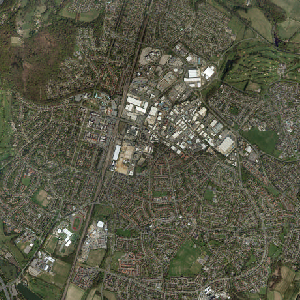
- Vertical, ortho-rectified aerial imagery covering all of Hertfordshire for 2010.
- Topic Category
- imageryBaseMapsEarthCover
- Keyword
- Keyword Value: Aerial Photography 2010
Originating Controlled Vocabulary: GEMET - INSPIRE Spatial Data Themes (GEMET)
Originating Controlled Vocabulary Citation: 2008-01-01 - Temporal Extent
- 2010
- Dataset Reference Date
- Date: -- 2010
Date Type: Creation - Lineage
-
Specification: Colour, vertical aerial photography to RICS specification, Quality: The photography shall be of an image quality and geometry suitable for photogrammetric mapping and raster scanning.
Its intended use includes land use interpretation, planning and engineering applications.Camera: Air survey camera,
Lens unit: 152mm focal length, calibrated, cleaned, tested and certified, Forward-motion compensator:Yes, Nominal scale: 1:10000, Flight lines: Straight and level, aligned North/South,
Lateral overlap 25% (between 15% and 35%),Forward overlap: 60% (between 55% and 65%), Camera orientation: Camera tilt shall not normally exceed 2 degrees and crab shall not exceed 5 degrees
Product: Orthophotography, Geo-referenced raster image, Minimum resolution True 1200dpi, Pixel/ground resolution: 25cm, Maximum viewing scale: 1:1250, Number of colours:24 bit
2000
To read about the methodology used to obtain the 2010 AP please see here - Extent
- Hertfordshire County
- Vertical Extent
- -
- Spatial Reference System
- OSGB36 - National Grid of Great Britain
- Spatial Resolution
- 1m
- Resource Locator
- Layerfile for use by HCC internal staff: \Geodata\AirPhoto\year2010
- Format
- ESRI/SDE
- Responsible Organisation
- Hertfordshire County Council - Corporate GIS Team
Email :gis@hertfordshire.gov.uk
Role: Resource Provider, Custodian, Owner, Distributor, Originator, Point of Contact, Processor, Publisher, Author. - Limitations on Public Access
- restricted public access to comply with intellectual property rights
- Use Constraints
- This data is supplied without guarantee or any warranty as to the accuracy, currency or completeness,
and is provided as is, excluding any warranties of any
kind, either express or implied, to the fullest extent permitted by law,including (but not limited to) satisfactory quality or fitness for a particular purpose.
- Additional information
- Resource Identifier
- Conformity
- Commission Regulation (EU) No 1089/2010 of 23 November 2010 implementing Directive 2007/2/EC of the European Parliament and of the Council
as regards interoperability of spatial data sets and services.
2010-12-08
notEvaluated
Re-designing HCC Data for INSPIRE not done - Equivalent scale
- Bounding box
- 0.76, 0.22, 51.58, 52.10
- Quality scope
- Dataset
- Spatial representation type
- vector
- Character encoding
- UTF-8
- Data quality
- -
- Maintenance information
- maintenance and update frequency:
- update scope:
- maintenance note:
- Metadata update date
- --
- Metadata Language
- English
- Metadata Point of Contact
- Hertfordshire County Council - Corporate GIS Team
Email :gis@hertfordshire.gov.uk - Resource Type
- 6 Dataset
- File Identifier
- Hierarchy level name
- dataset
- Parent identifier
- -
- Metadata standard name
- UK GEMINI
- Metadata standard version
- 2.3
- Review date
- -
- Attributes
-
Name Long Name Description
- OSGB36 National Grid Bounding Coordinates
- West: 486000 East: 552000 North: 245000 South: 189000
- More Information
- Change History
All rights reserved. The data remains the property of GeoPerspectives™. No part of this data may be reproduced, stored in or introduced into a retrieval system or transmitted,in any form, or by any means without the prior written permission of Bluesky International Ltd. or as specifically detailed in any supplementary GeoPerspectives™ License Agreement. Any infringement of this user agreement may render the perpetrator(s) liable to criminal prosecution and civil claims for damages. You must use the following Copyright Acknowledgement: Aerial Photography © GeoPerspectives.co.uk