Year 2010 aerial photography and digital imagery of Hertfordshire
In 2010 Hertfordshire County Council acquired aerial photography for the whole of Hertfordshire and some adjacent areas of interest.
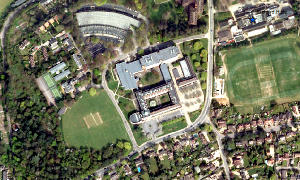
Aerial photographs are usually taken from an aircraft. Those held by HCC are vertical photographs, that is the camera points straight down at the ground and the photographs show the landscape in plan. Vertical photography is used in cartography, land-use planning, archaeology, environmental studies, and other fields. Vertical aerial photographs can also be used in GIS (Geographic Information Systems).
A second kind is known as oblique photography. Here the camera is directed at an angle towards the ground and the photographs show the side elevations of buildings. This type of photography is not widely used by HCC other than in property marketing.
Aerial photo of County Hall ©GeoPerspectives
The photographs are taken from an aircraft using a special digital on-board camera pointing directly down at the ground. These vertical aerial images are typically used for mapping and survey work; they are taken at high resolution at a low altitude and can be very accurate. They show a great deal of detail, for example buildings, trees and vehicles. Aerial images complement maps by showing us a view of the world that we are accustomed to but from a different perspective; the landscape may seem unfamiliar but the images are not difficult to interpret since photographs, unlike maps, do not have a symbology that needs to be understood before we can make sense of them.
Unfortunately aerial images do have one important disadvantage when compared to maps; scale distortions cause features to appear in incorrect positions. These distortions result from the aircraft not being able to fly a perfectly straight and level course and from changes in the elevation of the land beneath the aircraft. The aircraft is also buffeted by the wind moving it about in three dimensions (roll, pitch and yaw) so the camera is not always pointed directly downwards. Height distortion is introduced where undulations in the landscape occur causing differing ratios of flying height to the focal length of the camera, thus affecting the scale of the image. The worst of these distortions have to be removed or compensated for to allow the images to be used in mapping projects. This process is termed orthorectification. Each GeoPerspectives image has undergone orthorectification and the distortions are much reduced but can not be completely eliminated.
A second distortion is building lean, the apparent displacement of building roofs away from the centre of the photograph. This gets worse towards the edge of a image and is most apparent with tall structures. It is possible to remove building lean but then that part of the ground that was obscured by the building becomes blank; this can be patched with suitable imagery but the result is no longer a true reflection of the real world. No correction for building lean has been made in these images, and this can result in a rather odd effect in some areas
- HCC staff can access high quality imagery using ArcGIS or Webmaps-extra.
- Staff will find the digital images on the corporate GIS Server.
- The public can access the images through HertsDirect WebMaps.
- The aerial images may be purchased from Bluesky International Ltd - see the external link.
Whenever displaying aerial photography, you must use the following Copyright Acknowledgement:
Aerial Photography © GeoPerspectives.co.uk
For more information see the full
Metadata for Year 2010 Aerial Photography.