Metadata
Main Rivers
- Title
- Main Rivers
- Alternative Title
- Rivers, Main Rivers
-
- Dataset Language
- eng
- Abstract
-
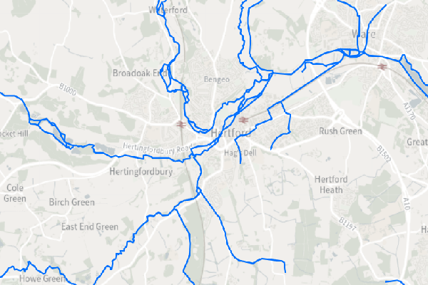
Statutory Main Rivers Map is a spatial (polyline) dataset that defines statutory watercourses in England designated as Main Rivers by the Environment Agency.
Watercourses designated as ‘main river’ are generally the larger arterial watercourses. The Environment Agency has permissive powers, but not a duty, to carry out maintenance,
improvement or construction work on designated main rivers.
All other open water courses in England are determined by statute as an ‘ordinary watercourse’. On these watercourses the Lead Local flood Authority or, if within an Internal Drainage District,
the Internal Drainage Board have similar permissive powers to maintain and improve.
© Environment Agency copyright and/or database right. Contains OS data © Crown copyright and database right (2023)
- Topic Category
- environment
- Keyword
- Keyword Value: Main Rivers, Rivers
Originating Controlled Vocabulary: GEMET - INSPIRE Spatial Data Themes (GEMET)
Originating Controlled Vocabulary Citation: 2008-01-01
- Temporal Extent
- from -1960- to -2013-04
- Dataset Reference Date
- Date:2011-08-10 -2013-04
Date Type:publication, revision
- Lineage
- This data is provided by the Environment Agency, which HCC take a copy of.
The site to download the data, or consume the data in a variety of other spatial formats, is here
IPR:
Product:
Date:
- Extent
- Hertfordshire County
- Vertical Extent
- -
- Spatial Reference System
- OSGB36 - National Grid of Great Britain
- Spatial Resolution
- 1m
- Resource Locator
-
- Within the eariver service
- Format
- ESRI/SDE
- Responsible Organisation
- Environment Agency
Please email DSPcustomerforum@environment-agency.gov.uk for any queries.
- Limitations on Public Access
- Copyright Controlled. Use is subject to licence.
- Use Constraints
- You must use the appropriate Copyright Acknowledgement;
© Environment Agency copyright and/or database right. Contains OS data © Crown copyright and database right (2023)
- Additional information
- Resource Identifier
- Conformity
- Commission Regulation (EU) No 1089/2010 of 23 November 2010 implementing Directive 2007/2/EC of the European Parliament and of the Council
as regards interoperability of spatial data sets and services.
2010-12-08
notEvaluated
Re-designing HCC Data for INSPIRE not done
- Equivalent scale
- Bounding box
- 0.76, 0.22, 51.58, 52.10
- Quality scope
- Dataset
- Spatial representation type
- vector
- Character encoding
- UTF-8
- Data quality
- -
- Maintenance information
- maintenance and update frequency:unknown
- update scope:
- maintenance note:
- Metadata update date
- -2021-11-29
- Metadata Language
- English
- Metadata Point of Contact
- Hertfordshire County Council - Corporate GIS Team
Email :gis@hertfordshire.gov.uk
- Resource Type
- 6 Dataset
- File Identifier
- Hierarchy level name
- dataset
- Parent identifier
- -
- Metadata standard name
- UK GEMINI
- Metadata standard version
- 2.3
- Review date
- -
- Attributes
-
| Name |
Long Name |
Description |
|
|
|
|
|
|
|
|
|
|
|
|
|
|
|
|
|
|
|
|
|
- OSGB36 National Grid Bounding Coordinates
- West: 486000 East: 552000
North: 245000 South: 189000
- More Information
- Change History