Metadata
EA Operational Areas
- Title
- EA Operational Areas
- Alternative Title
- Environment Agency Operational Areas
-
- Dataset Language
- eng
- Abstract
-
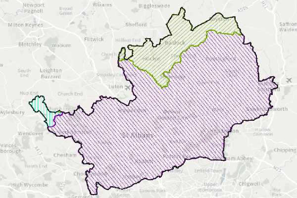
This dataset shows the geographical areas of the Environment Agency's operations. There are 15 Operational Areas in total, with Hertfordfordshire straddling
3 boundaries.
- Topic Category
- environment
- Keyword
- Keyword Value: Environment Agency, Areas
Originating Controlled Vocabulary: GEMET - INSPIRE Spatial Data Themes (GEMET)
Originating Controlled Vocabulary Citation: 2008-01-01
- Temporal Extent
- from -1960- to -2013-04
- Dataset Reference Date
- Date:2011-08-10 -2013-04
Date Type:publication, revision
- Lineage
- This data is provided by the Environment Agency, which HCC take a copy of. This can be reached here.
IPR:
Product:
Date:
- Extent
- Hertfordshire County
- Vertical Extent
- -
- Spatial Reference System
- OSGB36 - National Grid of Great Britain
- Spatial Resolution
- 1m
- Resource Locator
-
- Within the floodmanareas service
- Format
- ESRI/SDE
- Responsible Organisation
- Environment Agency
Please email enquiries@environment-agency.gov.uk for any queries.
- Limitations on Public Access
- Copyright Controlled. Use is subject to licence.
- Use Constraints
- You must use the appropriate Copyright Acknowledgement;
© Environment Agency copyright and/or database right. Contains OS data © Crown copyright and database right (2023)
- Additional information
- Resource Identifier
- Conformity
- Commission Regulation (EU) No 1089/2010 of 23 November 2010 implementing Directive 2007/2/EC of the European Parliament and of the Council
as regards interoperability of spatial data sets and services.
2010-12-08
notEvaluated
Re-designing HCC Data for INSPIRE not done
- Equivalent scale
- Bounding box
- 0.76, 0.22, 51.58, 52.10
- Quality scope
- Dataset
- Spatial representation type
- vector
- Character encoding
- UTF-8
- Data quality
- -
- Maintenance information
- maintenance and update frequency:unknown
- update scope:
- maintenance note:
- Metadata update date
- -2021-11-29
- Metadata Language
- English
- Metadata Point of Contact
- Hertfordshire County Council - Corporate GIS Team
Email :gis@hertfordshire.gov.uk
- Resource Type
- 6 Dataset
- File Identifier
- Hierarchy level name
- dataset
- Parent identifier
- -
- Metadata standard name
- UK GEMINI
- Metadata standard version
- 2.3
- Review date
- -
- Attributes
-
| Name |
Long Name |
Description |
|
|
|
|
|
|
|
|
|
|
|
|
|
|
|
|
|
|
|
|
|
- OSGB36 National Grid Bounding Coordinates
- West: 486000 East: 552000
North: 245000 South: 189000
- More Information
- Change History
