Metadata
Adult Care Service Flows
- Title
- ACS Flows
- Alternative Title
- Adult Care Service Flows
- Dataset Language
- eng
- Abstract
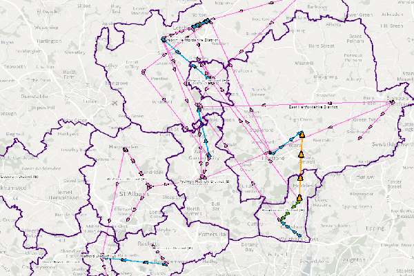
- Adult Care Service data for people recieving care as part of the Older People care budget. The arrows represent people moving between settlements from their home to a care provider
which is based on their home and care postcodes.
Settlements have been created by combining LSOAs in a bespoke manner to align with service goals.
The raw data is firstly processed by CIDS, who then hand it over to GIS to spatialise. - Topic Category
- Society
- Keyword
- Keyword Value: Adult Care
Originating Controlled Vocabulary: GEMET - INSPIRE Spatial Data Themes (GEMET)
Originating Controlled Vocabulary Citation: 2008-01-01 - Temporal Extent
- 2022 / 2023
- Dataset Reference Date
- Reference Data: from 2018 / 19 to 2020 / 23
Date Type: Revision - Lineage
-
The raw data comes from ROC_IAS, a read-only copy of the ACSIS system. The service groupings are defined on a yearly basis by ACS & CIDS based on lookup tables.
IPR: Ordnance Survey
Product: OS CodePoint
Date: 2023 - Extent
- Hertfordshire County
- Vertical Extent
- -
- Spatial Reference System
- OSGB36 - National Grid of Great Britain
- Spatial Resolution
- 1m
- Resource Locator
- This dataset is only available for HCC Members of Staff via the ACS Flow Map
- Format
- ESRI/File Geodatabase
- Responsible Organisation
- Hertfordshire County Council
Email :Alex Ogle@hertfordshire.gov.uk
Role: Resource Provider, Custodian, Owner, Originator, Point of Contact - Limitations on Public Access
- Formal permission required for use
- Use Constraints
- Copyright controlled Ordnance Survey Derived Data. Use is subject to licence.
-
You must use the appropriate Copyright Acknowledgement;
For internal use:©Crown copyright and database rights OS AC0000849954. Contains National Statistics data © Crown copyright and database rights 2023
- This data is supplied without guarantee or any warranty as to the accuracy, currency or completeness, and is provided as is, excluding any warranties of any kind, either express or implied, to the fullest extent permitted by law, including (but not limited to) satisfactory quality or fitness for a particular purpose.
- Additional information
-
-
- Resource Identifier
- ACS Flows
- Conformity
- Commission Regulation (EU) No 1089/2010 of 23 November 2010 implementing Directive
2007/2/EC of the European Parliament and of the Council as regards interoperability of
spatial data sets and services.
2010-12-08
notEvaluated
Re-designing HCC Data for INSPIRE not done - Equivalent scale
- Bounding box
- 0.76, 0.22, 51.58, 52.10
- Quality scope
- Dataset
- Spatial representation type
- vector
- Character encoding
- UTF-8
- Data quality
- -
- Maintenance information
- maintenance and update frequency: yearly
- update scope: dataset
- maintenance note:
- Metadata update date
- 2023-31-07
- Metadata Language
- English
- Metadata Point of Contact
- Hertfordshire County Council - Corporate GIS Team
Email :gis@hertfordshire.gov.uk - Resource Type
- 6 Dataset
- File Identifier
- ACS Flows
- Hierarchy level name
- dataset
- Parent identifier
- -
- Metadata standard name
- UK GEMINI
- Metadata standard version
- 2.3
- Review date
- -
- Attributes
-
Name Long Name Description
- OSGB36 National Grid Bounding Coordinates
- West: 486000 East: 552000 North: 245000 South: 189000
- More Information
- Change History