Metadata
Congestion Hotspots
- Title
- Congestion Hotspots
- Alternative Title
- Traffic, Congestion, Hotspots
- Dataset Language
- eng
- Abstract
- The reports for calculating free flow and peaks were generated using a Traffic Master (from DfT) database that HCC has built in house.
Following on from this a calculation was then applied to both Free Flow and Peak datasets to establish the ratio against free flow speeds.
A check list is applied to determine whether a junction should be identified as a congestion hotspot.
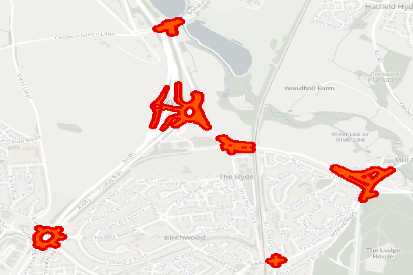
- This dataset shows the location of Congestion Hotspots based on junctions input file.
- Topic Category
- Keyword
- Keyword Value: Transport
Originating Controlled Vocabulary: GEMET - INSPIRE Spatial Data Themes (GEMET)
Originating Controlled Vocabulary Citation: 2008-01-01 - Temporal Extent
- Ongoing
- Dataset Reference Date
- Date: 22/11/2023
Date Type: Revision - Lineage
-
Dataset maintained by the custodians with the Highways Transport Planning and Data Team.
The data within this is maintained within our work program and this data feeds into the TTDR where it can also be viewed
IPR:
Product: OS MasterMap
Date: - Extent
- Hertfordshire County
- Vertical Extent
- -
- Spatial Reference System
- OSGB36 - National Grid of Great Britain
- Spatial Resolution
- 1m
- Resource Locator
- Public Webmap Viewer: Traffic Information Webmap Viewer
- Internal viewer for HCC staff: Highways Webmaps-extra Viewer
- This data is also visible in the TTDR with additional commentry
- Layerfile for use by HCC internal staff: Access via Portal
- Format
- ESRI/SDE
- Responsible Organisation
- Hertfordshire County Council
Email :Gary Beaumont@hertfordshire.gov.uk
Role: Resource Provider, Custodian, Owner, Originator, Point of Contact - Limitations on Public Access
- otherRestrictions
- Use Constraints
- Copyright controlled Ordnance Survey Derived Data. Use is subject to licence.
-
You must use the appropriate Copyright Acknowledgement;
For internal use:©Crown copyright and database rights Ordnance Survey 100019606.
For external use:©Crown copyright and database rights Ordnance Survey 100019606.
You are not permitted to copy, sub-licence, distribute or sell any of this data to third parties in any form.
For Publicly Available Electronic Copies the following must also be added:- The HCC Watermark;
- The phrase: "Use of this data is subject to terms and conditions." set out in a legible font and conspicuous position must form a clear hyperlink to https://gisinfo.hertfordshire.gov.uk/os/copyright.htm
- This data is supplied without guarantee or any warranty as to the accuracy, currency or completeness, and is provided as is, excluding any warranties of any kind, either express or implied, to the fullest extent permitted by law, including (but not limited to) satisfactory quality or fitness for a particular purpose.
- Additional information
- Congestion Hotspots
- Congestion Hotspots
This shows Congestion Hotspots within the date period shown above. - Resource Identifier
- Congestion Hotspots
- Conformity
- Commission Regulation (EU) No 1089/2010 of 23 November 2010 implementing Directive
2007/2/EC of the European Parliament and of the Council as regards interoperability of
spatial data sets and services.
2010-12-08
notEvaluated
Re-designing HCC Data for INSPIRE not done - Equivalent scale
- Bounding box
- 0.76, 0.22, 51.58, 52.10
- Quality scope
- Dataset
- Spatial representation type
- vector
- Character encoding
- UTF-8
- Data quality
- -
- Maintenance information
- maintenance and update frequency: yearly
- update scope: This layer will be yearly and feeds into the TTDR
- maintenance note:
- Metadata update date
- 2023-01-05
- Metadata Language
- English
- Metadata Point of Contact
- Hertfordshire County Council - Corporate GIS Team
Email :gis@hertfordshire.gov.uk - Resource Type
- 6 Dataset
- File Identifier
- Congestion Hotspots
- Hierarchy level name
- dataset
- Parent identifier
- -
- Metadata standard name
- UK GEMINI
- Metadata standard version
- 2.3
- Review date
- -
- Attributes
-
Name Long Name Description
- OSGB36 National Grid Bounding Coordinates
- West: 486000 East: 552000 North: 245000 South: 189000
- More Information
- Change History