Metadata
Natural Areas
- Title
- Natural_Areas
- Alternative Title
- Natural Areas
- Dataset Language
- eng
- Abstract
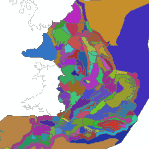
- Natural Areas are biogeographic zones that reflect the geological foundation, the natural
systems and processes and the wildlife in different parts of England.
There are 120 Natural Areas, many of which are coincident with Character Areas;
the remainder comprise one or more Character Area. Natural Areas are a sensible scale at which to view the wildlife resource, from both a national and local perspective, and they are used by English Nature as an ecologically coherent framework for setting objectives for nature conservation. Natural Areas are not a designation. - Topic Category
- environment
- Keyword
- Keyword Value:OpenData
Originating Controlled Vocabulary: GEMET - INSPIRE Spatial Data Themes (GEMET)
Originating Controlled Vocabulary Citation: 2008-01-01 - Temporal Extent
- from -- to -2010-11-24
- Dataset Reference Date
- Date: -2010-11-24
Date Type: revision - Lineage
- Not Available
IPR:
Product:
Date: - Extent
- National
- Vertical Extent
- -
- Spatial Reference System
- OSGB36 - National Grid of Great Britain
- Spatial Resolution
- 1m
- Resource Locator
- Layerfile for use by HCC internal staff:\\geodata\NatEng\NatArea
- Format
- ESRI/SDE
- Responsible Organisation
- Natural England
Email :data.services@naturalengland.org.uk
Role: Resource Provider, Custodian, Owner, Originator, Point of Contact, Processor, Publisher, Author. - Limitations on Public Access
- There are no public access constraints to this data. Use of this data is subject to the licence identified.
- Use Constraints
- This data is supplied without guarantee or any warranty as to the accuracy, currency or completeness,
and is provided as is, excluding any warranties of any
kind, either express or implied, to the fullest extent permitted by law,including (but not limited to) satisfactory quality or fitness for a particular purpose.
- Additional information
- This data is no longer available through Data.Gov.uk - Contact Natural England for access
- Resource Identifier
- Conformity
- Commission Regulation (EU) No 1089/2010 of 23 November 2010 implementing Directive 2007/2/EC of the European Parliament and of the Council
as regards interoperability of spatial data sets and services.
2010-12-08
notEvaluated
Re-designing HCC Data for INSPIRE not done - Equivalent scale
- Bounding box
- Not Available
- Quality scope
- Dataset
- Spatial representation type
- vector
- Character encoding
- UTF-8
- Data quality
- -
- Maintenance information
- maintenance and update frequency:NotPlanned
- update scope:
- maintenance note:
- Metadata update date
- -2021-07
- Metadata Language
- English
- Metadata Point of Contact
- Natural England
Email :data.services@naturalengland.org.uk
Role: Resource Provider, Custodian, Owner, Originator, Point of Contact, Processor, Publisher, Author. - Resource Type
- 6 Dataset
- File Identifier
- Hierarchy level name
- dataset
- Parent identifier
- -
- Metadata standard name
- UK GEMINI
- Metadata standard version
- 2.3
- Review date
- -
- Attributes
-
Name Long Name Description
- OSGB36 National Grid Bounding Coordinates
- West: 486000 East: 552000 North: 245000 South: 189000
- More Information
- Change History
Open Government Licence