Metadata
National Character Areas (England)
- Title
- National Character Areas (England)
- Alternative Title
- NCA
- Dataset Language
- eng
- Abstract
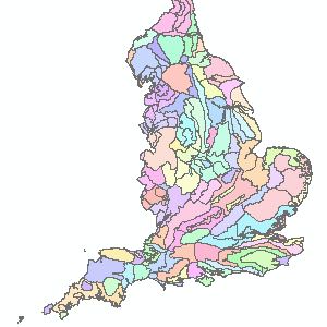
- There are 159 Character Areas, each of which is distinctive with a unique 'sense of place'. These broad divisions of landscape form the basic units of cohesive countryside character, on which strategies for both ecological and landscape issues can be based.
The Character Area framework is used to describe and shape objectives for the countryside, its planning and management. Attribution statement:
Attribution statement: © Natural England copyright. Contains Ordnance Survey data © Crown copyright and database right [year]. - Topic Category
- environment
- Keyword
- Keyword Value:Environment, Land Cover, OpenData
Originating Controlled Vocabulary: GEMET - INSPIRE Spatial Data Themes (GEMET)
Originating Controlled Vocabulary Citation: 2008-01-01 - Temporal Extent
- from -- to -2099-12-31
- Dataset Reference Date
- Date-2010-01-13 -2008-06-01
Date Type: publication, revision - Lineage
- No Lineage Available
-
IPR:
Product:
Date: - Extent
- National
- Vertical Extent
- -
- Spatial Reference System
- OSGB36 - National Grid of Great Britain
- Spatial Resolution
- 1m
- Resource Locator
-
https://naturalengland-defra.opendata.arcgis.com/datasets/national-character-areas-england
protocol: WWW:LINK-1.0-http--link
name: ArcGIS Open Dataset record page
description: ArcGIS Open Dataset record page
https://environment.data.gov.uk/DefraDataDownload/?mapService=NE/NationalCharacterAreasEngland&Mode=spatial
protocol: DSP:ESRI
name: NationalCharacterAreasEngland_Download
description: National Character Areas (England) Download
https://environment.data.gov.uk/spatialdata/national-character-areas-england/wfs
protocol: WFS
name: NationalCharacterAreasEngland_WFS
description: National Character Areas (England) WFS
https://environment.data.gov.uk/spatialdata/national-character-areas-england/wms
protocol: WMS
name: NationalCharacterAreasEngland_WMS
description: National Character Areas (England) WMS - Layerfile for use by HCC internal staff:\\geodata\NatEng\CharArea\
- Format
- ESRI/SDE
- Responsible Organisation
- Natural England
Email :data.services@naturalengland.org.uk
Role: Resource Provider, Custodian, Owner, Originator, Point of Contact, Processor, Publisher, Author. - Limitations on Public Access
- There are no public access constraints to this data. Use of this data is subject to the licence identified.
- Use Constraints
- This data is supplied without guarantee or any warranty as to the accuracy, currency or completeness,
and is provided as is, excluding any warranties of any
kind, either express or implied, to the fullest extent permitted by law,including (but not limited to) satisfactory quality or fitness for a particular purpose.
- Additional information
- Resource Identifier
- Conformity
- Commission Regulation (EU) No 1089/2010 of 23 November 2010 implementing Directive 2007/2/EC of the European Parliament and of the Council
as regards interoperability of spatial data sets and services.
2010-12-08
notEvaluated
Re-designing HCC Data for INSPIRE not done - Equivalent scale
- Bounding box
- -5.71709, 1.76896, 55.8117, 49.955400000000004
- Quality scope
- Dataset
- Spatial representation type
- vector
- Character encoding
- UTF-8
- Data quality
- -
- Maintenance information
- maintenance and update frequency:NotPlanned
- update scope:
- maintenance note:
- Metadata update date
- -2021-07
- Metadata Language
- English
- Metadata Point of Contact
- Natural England
Email :data.services@naturalengland.org.uk
Role: Resource Provider, Custodian, Owner, Originator, Point of Contact, Processor, Publisher, Author. - Resource Type
- 6 Dataset
- File Identifier
- Hierarchy level name
- dataset
- Parent identifier
- -
- Metadata standard name
- UK GEMINI
- Metadata standard version
- 2.3
- Review date
- -
- Attributes
-
Name Long Name Description
- OSGB36 National Grid Bounding Coordinates
- West: 486000 East: 552000 North: 245000 South: 189000
- More Information
- Change History
Open Government Licence