Metadata
National Nature Reserves (England)
- Title
- National Nature Reserves (England)
- Alternative Title
- NNR
- Dataset Language
- eng
- Abstract
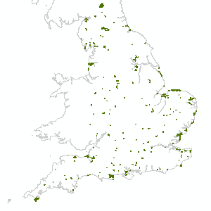
- A National Nature Reserve (NNR) is the land declared under the National Parks and Access to the Countryside Act 1949 or Wildlife and Countryside Act (1981) as amended.
The data does not include "proposed" sites. Supplied in England-wide and 100 x 100km tiles. Boundaries are mapped against Ordnance Survey MasterMap.
Attribution statement: © Natural England copyright. Contains Ordnance Survey data © Crown copyright and database right [year]. - Topic Category
- environment
- Keyword
- Keyword Value: Environment, LandUse, OpenData
Originating Controlled Vocabulary: GEMET - INSPIRE Spatial Data Themes (GEMET)
Originating Controlled Vocabulary Citation: 2008-01-01 - Temporal Extent
- from -1970-01-01 to -2099-12-31
- Dataset Reference Date
- Date:2016-03-01 -2021-04-15
Date Type:publication, revision - Lineage
- All data is captured to the Ordnance Survey National Grid sometimes called the British National Grid. OS MasterMap Topographic Layer produced and supplied by Ordnance Survey from data at
1:1250, 1:2500 and 1:10000 surveying and mapping standards - is used as the primary source. Other sources acquired internally and from external suppliers
- may include aerial imagery at resolutions ranging from 25cm to 2m, Ordnance Survey 1:10000 raster images, historical OS mapping, charts and chart data from UK Hydrographic Office and other sources,
scanned images of paper designation mapping (mostly originally produced at 1:10560 or 1:10000 scales), GPS and other surveyed data, and absolute coordinates.
The data was first captured against an August 2002 cut of OS MasterMap Topography. Natural England has successfully uploaded an up-to-date version of OS MasterMap Topographic Layer.
However, we have not yet updated our designated data holding to this new version of MasterMap. This should occur in the near future, when we will simultaneously apply positional accuracy improvement (PAI) to our data.
IPR:
Product:
Date: - Extent
- National
- Vertical Extent
- -
- Spatial Reference System
- OSGB36 - National Grid of Great Britain
- Spatial Resolution
- 1m
- Resource Locator
-
https://naturalengland-defra.opendata.arcgis.com/datasets/national-nature-reserves-england
protocol: WWW:LINK-1.0-http--link
name: ArcGIS Open Dataset record page
description: ArcGIS Open Dataset record page
https://environment.data.gov.uk/DefraDataDownload/?mapService=NE/NationalNatureReservesEngland&Mode=spatial
protocol: DSP:ESRI
name: NationalNatureReservesEngland_Download
description: National Nature Reserves (England) Download
https://environment.data.gov.uk/spatialdata/national-nature-reserves-england/wfs
protocol: OGC:WFS
name: NationalNatureReservesEngland_WFS
description: National Nature Reserves (England) WFS
https://environment.data.gov.uk/spatialdata/national-nature-reserves-england/wms
protocol: OGC:WMS
name: NationalNatureReservesEngland_WMS
description: National Nature Reserves (England) WMS <\dd>- Layerfile for use by HCC internal staff://geodata/NatEng/NNR
- Format
- ESRI/SDE
- Responsible Organisation
- Natural England
Email :data.services@naturalengland.org.uk
Role: Resource Provider, Custodian, Owner, Originator, Point of Contact, Processor, Publisher, Author. - Limitations on Public Access
- There are no public access constraints to this data. Use of this data is subject to the licence identified.
- Use Constraints
- This data is supplied without guarantee or any warranty as to the accuracy, currency or completeness,
and is provided as is, excluding any warranties of any
kind, either express or implied, to the fullest extent permitted by law,including (but not limited to) satisfactory quality or fitness for a particular purpose.
- Additional information
- Resource Identifier
- Conformity
- Commission Regulation (EU) No 1089/2010 of 23 November 2010 implementing Directive 2007/2/EC of the European Parliament and of the Council
as regards interoperability of spatial data sets and services.
2010-12-08
notEvaluated
Re-designing HCC Data for INSPIRE not done - Equivalent scale
- Bounding box
- -5.26562, 2.03262, 55.6566, 49.9597
- Quality scope
- Dataset
- Spatial representation type
- vector
- Character encoding
- UTF-8
- Data quality
- -
- Maintenance information
- maintenance and update frequency:NotPlanned
- update scope:
- maintenance note:
- Metadata update date
- -2021-07
- Metadata Language
- English
- Metadata Point of Contact
- Natural England
Email :data.services@naturalengland.org.uk
Role: Resource Provider, Custodian, Owner, Originator, Point of Contact, Processor, Publisher, Author. - Resource Type
- 6 Dataset
- File Identifier
- Hierarchy level name
- dataset
- Parent identifier
- -
- Metadata standard name
- UK GEMINI
- Metadata standard version
- 2.3
- Review date
- -
- Attributes
-
Name Long Name Description
- OSGB36 National Grid Bounding Coordinates
- West: 486000 East: 552000 North: 245000 South: 189000
- More Information
- Change History
Open Government Licence