Metadata
Sand And Gravel Belt
- Title
- SandandGravelBelt
- Alternative Title
- SAGB
- Dataset Language
- eng
- Abstract
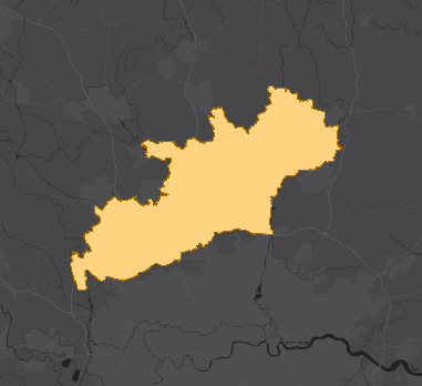
- Sand and gravel deposits are found in most parts of the county although they are concentrated in that part of Hertfordshire
south of a line between Bishops Stortford in the east and Hemel Hempstead in the west (often referred to as the sand and gravel belt). The sand and gravel belt is published in the
Hertfordshire Minerals Local Plan (Adopted 2007). The purpose of the Sand and Gravel Belt is as a consultation trigger to ensure that District/Borough councils consult
the County Council before determining application for development in order to safeguard mineral deposits that are, or may become, of economic importance from unnecessary sterilisation by surface development. - Topic Category
- geoscientificInformation
- Keyword
- Keyword Value: Environment, Gravel, Minerals, Resources, Sand
Originating Controlled Vocabulary: GEMET - INSPIRE Spatial Data Themes (GEMET)
Originating Controlled Vocabulary Citation: 2008-01-01 - Temporal Extent
- from -2002 to -2023
- Dataset Reference Date
- Date:2002 -2007
Date Type: creation, publication - Lineage
-
IPR:Ordnance Survey
Product: 1:10000 Mapping
Date:2002 -
IPR:Ordnance Survey
Product: Boundary Line
Date:2002 -
IPR:National Environment Reseach Council
Product: BGS 1:50000 Minerals
Date: 2002
Data is derived from Britsh Geological Society's minerals data and modified for council purposes using ESRI ArcGIS Software - Extent
- Hertfordshire County
- Vertical Extent
- -
- Spatial Reference System
- OSGB36 - National Grid of Great Britain
- Spatial Resolution
- 1m
- Resource Locator
- Layerfile for use by HCC internal staff:\\Geodata\HCC\Environ\Minerals\MLP_Adopted2007\Sand And Gravel Belt.Lyr
- Format
- ESRI/SDE
- Responsible Organisation
- Hertfordshire County Council - Environment and Infrastructure
Email :daniel.clark@hertfordshire.gov.uk
Role: Resource Provider, Custodian, Point of Contact. - Limitations on Public Access
- Copyright Controlled. Use is subject to licence.
- Use Constraints
- You must use the appropriate Copyright Acknowledgement;
For internal use:©Crown copyright and database rights Ordnance Survey AC0000849954.
For external use:© Crown copyright and database rights Ordnance Survey AC0000849954.
You are not permitted to copy, sub-licence, distribute or sell any of this data to third parties in any form.
For Publicly Available Electronic Copies the following must also be added:- The HCC Watermark;
- The phrase: "Use of this data is subject to terms and conditions." set out in a legible font and conspicuous position must form a clear hyperlink to the Ordnance Survey Copyright
-->
- This data is supplied without guarantee or any warranty as to the accuracy, currency or completeness,
and is provided as is, excluding any warranties of any
kind, either express or implied, to the fullest extent permitted by law,including (but not limited to) satisfactory quality or fitness for a particular purpose.
- Additional information
- Resource Identifier
- Conformity
- Commission Regulation (EU) No 1089/2010 of 23 November 2010 implementing Directive 2007/2/EC of the European Parliament and of the Council
as regards interoperability of spatial data sets and services.
2010-12-08
notEvaluated
Re-designing HCC Data for INSPIRE not done - Equivalent scale
- Bounding box
- 0.76, 0.22, 51.58, 52.10
- Quality scope
- Dataset
- Spatial representation type
- vector
- Character encoding
- UTF-8
- Data quality
- -
- Maintenance information
- maintenance and update frequency:notPlanned
- update scope:
- maintenance note:
- Metadata update date
- 2021-11-19
- Metadata Language
- English
- Metadata Point of Contact
- Hertfordshire County Council - Corporate GIS Team
Email :gis@hertfordshire.gov.uk - Resource Type
- 6 Dataset
- File Identifier
- Hierarchy level name
- dataset
- Parent identifier
- -
- Metadata standard name
- UK GEMINI
- Metadata standard version
- 2.3
- Review date
- -
- Attributes
-
Name Long Name Description
- OSGB36 National Grid Bounding Coordinates
- West: 486000 East: 552000 North: 245000 South: 189000
- More Information
- Change History
The data contains British Geological Survey intelectual property © NERC. All rights Reserved. Based upon 1:50,000 geological maps, with the permission of the British Geological Survey.