Metadata
Mineral Consultation Areas
- Title
- MineralConsultationAreas
- Alternative Title
- Mineral Consultation Areas, MCA, MCA2007
- Dataset Language
- eng
- Abstract
-
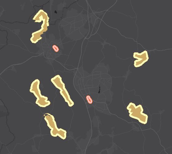
Mineral Consultation Areas identified within the Supplementary Planning Document (adopted November 2007), to assist the implementation of the Minerals Local Plan.
The Minerals Consultation Areas (MCAs) consist of mineral sterilisation MCAs and railhead MCAs.
The Mineral Sterilisation MCAs (also know as Minerals Resource Blocks) are areas that have been identified where particular care is needed to prevent the unnecessary
sterilisation of sand and gravel resources and to safeguard rail aggregates depots.
The sand and gravel belt and mineral resource blocks outside of this are included for minerals.
The railhead MCAs (also known as Rail Aggregates Depots) are existing operational and/or disused rail aggregates depots (as of March 2007, as identified in the Minerals
Local Plan, adopted March 2007 and Minerals Consultation Areas Supplementary Planning Document, adopted November 2007) identified for their protection
for the transportation of minerals by rail.
Buffer zones at 250m around the mineral resource blocks and railheads exist to allow consideration of the impact of development close to but outside of the sites. - Topic Category
- geoscientificInformation
- Keyword
- Keyword Value:Consultation Areas, Geology, Hertfordshire, MCA, MCA2007, Minerals Resources,
Originating Controlled Vocabulary: GEMET - INSPIRE Spatial Data Themes (GEMET)
Originating Controlled Vocabulary Citation: 2008-01-01 - Temporal Extent
- from -2007-11-20 to --
- Dataset Reference Date
- Date:2007-11-20 --
Date Type: publication - Lineage
-
IPR:Ordnance Survey
Product:1:10,000 Raster
Date:2007
IPR:Ordnance Survey
Product:MasterMap
Date:2007
IPR:National Environment Reseach Council
Product:British Geological Survey 1:50,000 Data
Date:2007
IPR:Environment Agency
Product: Flood Map
Date:2007
IPR:Hertfordshire County Council's Intellectual Property Rights - Extent
- Hertfordshire County
- Vertical Extent
- -
- Spatial Reference System
- OSGB36 - National Grid of Great Britain
- Spatial Resolution
- 1m
- Resource Locator
- Layerfile for use by HCC internal staff:\\Geodata\HCC\Environ\Minerals\MCA2008Minerals Consultation Areas 2008.lyr
- Format
- ESRI/SDE, ESRI/Shape file
- Responsible Organisation
- Hertfordshire County Council - Environment and Infrastructure
Email :daniel.clark@hertfordshire.gov.uk
Role: Resource Provider, Custodian, Point of Contact. - Limitations on Public Access
- Copyright Controlled. Use is subject to licence.
- Use Constraints
- You must use the appropriate Copyright Acknowledgement;
For internal use:©Crown copyright and database rights Ordnance Survey 100019606.
For external use:© Crown copyright and database rights Ordnance Survey 100019606.
You are not permitted to copy, sub-licence, distribute or sell any of this data to third parties in any form.
For Publicly Available Electronic Copies the following must also be added:- The HCC Watermark;
- The phrase: "Use of this data is subject to terms and conditions." set out in a legible font and conspicuous position must form a clear hyperlink to the Ordnance Survey Copyright
- This data is supplied without guarantee or any warranty as to the accuracy, currency or completeness,
and is provided as is, excluding any warranties of any
kind, either express or implied, to the fullest extent permitted by law,including (but not limited to) satisfactory quality or fitness for a particular purpose. - Additional information
- Resource Identifier
- Conformity
- Commission Regulation (EU) No 1089/2010 of 23 November 2010 implementing Directive 2007/2/EC of the European Parliament and of the Council
as regards interoperability of spatial data sets and services.
2010-12-08
notEvaluated
Re-designing HCC Data for INSPIRE not done - Equivalent scale
- Bounding box
- 0.76, 0.22, 51.58, 52.10
- Quality scope
- Dataset
- Spatial representation type
- vector
- Character encoding
- UTF-8
- Data quality
- -
- Maintenance information
- maintenance and update frequency:notPlanned
- update scope:
- maintenance note:
- Metadata update date
- -2021-11-19
- Metadata Language
- English
- Metadata Point of Contact
- Hertfordshire County Council - Corporate GIS Team
Email :gis@hertfordshire.gov.uk - Resource Type
- 6 Dataset
- File Identifier
- Hierarchy level name
- dataset
- Parent identifier
- -
- Metadata standard name
- UK GEMINI
- Metadata standard version
- 2.3
- Review date
- -
- Attributes
-
Name Long Name Description
- OSGB36 National Grid Bounding Coordinates
- West: 486000 East: 552000 North: 245000 South: 189000
- More Information
- Change History
The data contains British Geological Survey intelectual property © NERC. All rights Reserved. Based upon 1:50,000 geological maps, with the permission of the British Geological Survey.