Metadata
Clean Air and Health Matrix
- Title
- Clean Air Health Matrix
- Alternative Title
- Air Quality Matrix
- Dataset Language
- eng
- Abstract
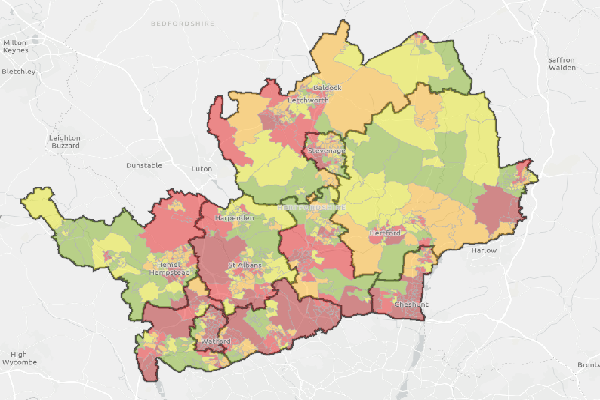
- The Clean Air and Health Matrix collates data from a range of health sources including those with a specific clean air focus. The data from each indicator is scored individually at
Lower Social Output Area (LSOA) scale before a weighting is applied and the scores combined The combined scores are then ranked by quintile to provide a list of LSOA's which are deemed
highest priority through to low priority. The indicators include:
- Proximity to Air Quality Management Areas (AQMA's), the closer to an AQMA the higher the score. AQMA's are areas where national legal polution levels are exceeded.
- PM2.5 Concentration - the higher the concentration the higher the score
- Index of Multiple Deprivation 2019 - an indiex taking factors which enable the identification of the most and least deprived LSOA's in the county. The more deprived an area the higher the score.
- ACORN Health "Wellbeing" data - a national dataset where health characteristics of communities is analysed. The more health deprived the lower the score.
- Population number - the larger the population the higher the score
- Number of sensitive receptors to poor air quality - the more receptors (placed in health and educational settings) the higher the score.
- Congestion Hotspots - identified congestion points based on 2015/2016 Traffic Master Teletrac data. The more congested points in an area the higher the score
- Canopy Cover - the lower the canopy cover the higher the score.
- Topic Category
- environment
- Keyword
- Keyword Value: Clean Air and Health Matrix
Originating Controlled Vocabulary: GEMET - INSPIRE Spatial Data Themes (GEMET)
Originating Controlled Vocabulary Citation: 2008-01-01 - Temporal Extent
- n/a
- Dataset Reference Date
- Date: 28/06/2022
Date Type: revision - Lineage
- The above indicators used to create the matrix come from a range of sources:
- Proximity to Air Quality Management Areas -DEFRA UK AIR. This is an air information resource (2022).
- PM 2.5 Concentration -DEFRA UK AIR. This is an air information resource which maps data for local Authorities (2018).
- Index of Multiple Deprivation - English Indices of Deprivation 2019. Created by the Ministry of Housing, Communities and Local Government (2019).
- ACORN health "Wellbeing" data -Please see metadata information here. Data created by CACI (2021)
- Population number -Population Mid Year Estimates 2020. Data owned by the Office for National Statistics.
- Number of sensitive receptors to poor air quality - taken from internal GIS datasets and includes HCC owned schools, GP Surgeries, Hospital Sites and pharmacies
- Congestion points -Please see metadata information here.Used data from December 2020, and included Trunk, Primary & Secondary roads and compares average speeds against registered speed limits on approaches to junctions
- Canopy Cover - Tree Canopy Data based on mapped tree data via the Biodiversity Baseline and uses an indicator for lower canopy cover of 15%
IPR: Ordnance Survey
Product:
Date: - Extent
- Hertfordshire County
- Vertical Extent
- -
- Spatial Reference System
- OSGB36 - National Grid of Great Britain
- Spatial Resolution
- Resource Locator
- Internal only - Air Quality Extra Viewer
- Format
- ESRI/SDE
- Responsible Organisation
- Hertfordshire County Council - Cleaner Air Programme Management
Email :cleaner.air@hertfordshire.gov.uk
Role: Resource Provider, Custodian, Owner, Distributor, Originator, Point of Contact, Processor, Publisher, Author. - Limitations on Public Access
- OtherRestrictions
- Use Constraints
- You must use the appropriate Copyright Acknowledgement;
For internal use:©Crown copyright and database rights Ordnance Survey 100019606.
For external use:© Crown copyright and database rights Ordnance Survey 100019606.
You are not permitted to copy, sub-licence, distribute or sell any of this data to third parties in any form.
For Publicly Available Electronic Copies the following must also be added:- The HCC Watermark;
- The phrase: "Use of this data is subject to terms and conditions." set out in a legible font and conspicuous position must form a clear hyperlink to the Ordnance Survey Copyright
- This data is supplied without guarantee or any warranty as to the accuracy, currency or completeness,
and is provided as is, excluding any warranties of any
kind, either express or implied, to the fullest extent permitted by law,including (but not limited to) satisfactory quality or fitness for a particular purpose.
- Additional information
- Resource Identifier
- Conformity
- Commission Regulation (EU) No 1089/2010 of 23 November 2010 implementing Directive 2007/2/EC of the European Parliament and of the Council
as regards interoperability of spatial data sets and services.
2010-12-08
notEvaluated
Re-designing HCC Data for INSPIRE not done - Equivalent scale
- Bounding box
- 0.76, 0.22, 51.58, 52.10
- Quality scope
- Dataset
- Spatial representation type
- vector
- Character encoding
- UTF-8
- Data quality
- -
- Maintenance information
- maintenance and update frequency: AsNeeded
- update scope:
- maintenance note:
- Metadata update date
- -2023-07-14
- Metadata Language
- English
- Metadata Point of Contact
- Hertfordshire County Council - Corporate GIS Team
Email :gis@hertfordshire.gov.uk - Resource Type
- 6 Dataset
- File Identifier
- Hierarchy level name
- dataset
- Parent identifier
- -
- Metadata standard name
- UK GEMINI
- Metadata standard version
- 2.3
- Review date
- -
- Attributes
-
Name Long Name Description
- OSGB36 National Grid Bounding Coordinates
- West: 486000 East: 552000 North: 245000 South: 189000
- More Information
- Change History
Use of the data is available to any organisation that is a member of the PSGA (Public Sector Geospatial Agreement) or any UK academic institution via Edina's subscription Digimap service. It is not currently commercially available.