Spatial Data Models
There are two main computer models used in GIS to represent geographic features; they are known as spatial data models.
In the first, the vector data model, each feature is defined spatially with discrete Easting and Northing co-ordinate pairs. In the second, the raster data model, the data is displayed as an image laid out in a grid structure where each cell, or pixel, is referenced by a particular row and column value.
The Vector Data Model
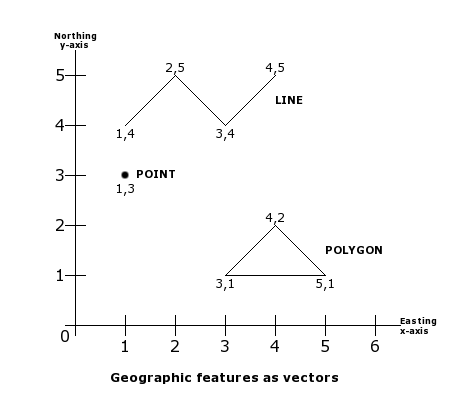
In a vector data model, locations are recorded as Easting and Northing co-ordinates. Points are recorded as a single co-ordinate pair, lines are recorded as a series of ordered co-ordinate pairs and areas (polygons) are recorded as a series of ordered co ordinate pairs defining line segments that enclose an area.
This method means that you can look at the map feature at any scale and it will always be clear.
The Raster Data Model
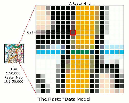
The raster data model is a rectangular grid of cells (pixels) each with a value. Using the raster data model, the earth is treated as one continuous surface and data is stored as a picture, just like a digital photograph of a paper map.
Each cell or pixel represents a rectangular area on the ground; the matrix of cells, organised into rows and columns, is called a grid. Each cell has a value; cell values are numbers that represent nominal data such as land use classes or vegetation type, or they may be measurements such as elevation.
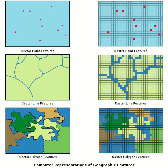
Like the vector model, the raster data model can represent discrete point, line and area features. A point feature is represented as a value of a single cell, a linear feature as a series of connected cells that can portray any length, and an area feature as a group of connected cells portraying shape.
Raster data is geo-referenced by specifying the co-ordinate system to which a grid is registered, the real world location of the reference point and the cell size in real world distances. Typically, the upper left or lower left corner of the grid is used as the reference point. The reference point location, along with the cell size, can be used to determine the geographic location of any cell within the raster dataset.
The precision of a map depends upon the scale of the map. While the Vector Model holds precise co-ordinates for each location the raster data is based upon a grid. The resolution of the Raster Model therefore depends on the real world area represented by each grid cell; the smaller the cell size, the greater the precision. Raster data must be viewed at the correct scale; in the same way that digital photographs become blurred when viewed close up, so do raster data pixels.